Upper Wakarusa Watershed Cover Crop Study
Purpose: Test yield response and Soil Health Benefits of varying cover crop planting practices.
Goal: To identify, measure, and quantify best management practices for planting covers on crop ground in the Upper Wakarusa Watershed (UWW).
Partners: The team consists of: Andrew Rutter Upper Wakarusa WRAPS Coordinator, Justin Hamilton, Manager of Clinton Wildlife Land, Kaitlin Gibbon, Conservation Agronomist, Suzy Mooney, Douglas County Conservation District, and Kevin Lane, Operator. Kansas State University researchers Dr. Eric Adee and Dr. Anita Dille providing guidance for carrying out the project. NRCS Soil Scientist, Matalyn E. Stark and Brian Nester.
About the field: The test field in located in the Clinton Wildlife Area and is adjacent to the KDWPT office in Douglas County. Composed of approximately 11.4 acres of KDWT - managed land the field is currently in a corn and soybean rotation. Using the Web Soil Survey
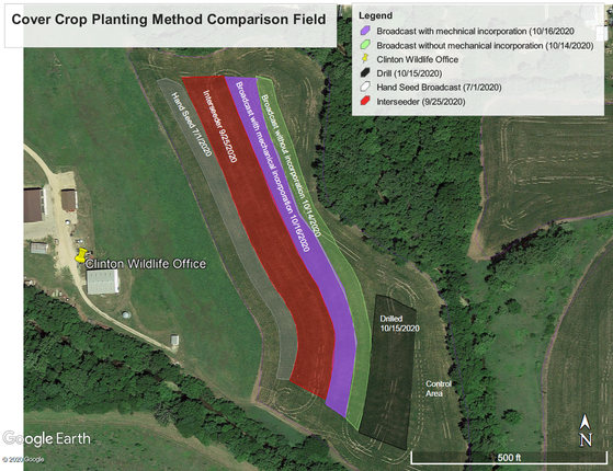
Five different seeding methods will be carried out using a diverse seed mix purchased and on-site at the KDWPT facility.
Baseline Soil Sample taken 4/14
KSU Soil Lab Results
Rainfall Simulator Demo on 6/8/2020
Corn was planted sometime between 4/15 and 4/17/2020. The previous year’s crop was also corn.
Baseline water infiltration test was conducted on 06/08/2020 using a rainfall simulator.
We will continue to post updates and observations on …. Please follow us.
Goal: To identify, measure, and quantify best management practices for planting covers on crop ground in the Upper Wakarusa Watershed (UWW).
Partners: The team consists of: Andrew Rutter Upper Wakarusa WRAPS Coordinator, Justin Hamilton, Manager of Clinton Wildlife Land, Kaitlin Gibbon, Conservation Agronomist, Suzy Mooney, Douglas County Conservation District, and Kevin Lane, Operator. Kansas State University researchers Dr. Eric Adee and Dr. Anita Dille providing guidance for carrying out the project. NRCS Soil Scientist, Matalyn E. Stark and Brian Nester.
About the field: The test field in located in the Clinton Wildlife Area and is adjacent to the KDWPT office in Douglas County. Composed of approximately 11.4 acres of KDWT - managed land the field is currently in a corn and soybean rotation. Using the Web Soil Survey
Five different seeding methods will be carried out using a diverse seed mix purchased and on-site at the KDWPT facility.
- Broadcast seeding into a standing crop midseason
- Broadcast seeding into a standing crop at or near maturity. In crop year 2020, an interseeder was used to seed the covers into the into a standing corn crop just weeks before harvest.
- Broadcasting following harvest
- Broadcasting following harvest with operators using their equipment to mechanically incorporate the seed.
- Drilling following harvest using KDWPT 10’ no-till drill
Baseline Soil Sample taken 4/14
KSU Soil Lab Results
Rainfall Simulator Demo on 6/8/2020
Corn was planted sometime between 4/15 and 4/17/2020. The previous year’s crop was also corn.
Baseline water infiltration test was conducted on 06/08/2020 using a rainfall simulator.
We will continue to post updates and observations on …. Please follow us.